|
|
|

|
|
U.S. military's experimental tactical satellite to launch BY STEPHEN CLARK SPACEFLIGHT NOW Posted: May 3, 2009 A military satellite designed to demonstrate inexpensive user-friendly space technologies is being readied for launch from Virginia's Eastern Shore on Tuesday night.
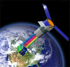
The 69-foot-tall rocket is scheduled to blast off at 8 p.m. EDT Tuesday. The launch window extends for three hours. It will be the third Minotaur launch since 2006 from pad 0B at the Mid-Atlantic Regional Spaceport at Wallops Island, Va. Around 50 workers have spent more than a month at Wallops preparing the solid-fueled launcher and its payloads for liftoff, according to Jack Vieira, the TacSat 3 project manager at the launch site. The Minotaur is also loaded with a small NASA biology research satellite and three tiny CubeSat payloads. Another 400 official guests are expected to flood the Eastern Shore by launch day, Vieira said. Officials are not working any major issues this weekend, but it has been a long road to launch for TacSat 3. Engineers examined the Minotaur's payload fairing to make sure Tuesday's $88 million launch would not suffer the same fate as the February flight of a Taurus rocket that was brought down when its nose cone failed to jettison. The fairing protects the payload as the rocket accelerates through the lower atmosphere. The structure separates in two halves a few minutes after launch. "Certainly there was a reason to go look at that," said Air Force Col. Scott Handy, mission director for the launch. As it turns out, the Minotaur fairing shares very little in common with hardware on the Taurus. Officials exonerated the fairing's frangible rails in the Taurus failure. A similar system is used by the Minotaur 1. "Those particular rails go along the base of the fairing as well as around the exterior so that the two fairing halves can actually separate at the time during the mission," Handy said. Orbital and NASA, the customer for the doomed February launch, are still reviewing the Taurus mishap, but the investigators briefed the Minotaur team on their interim results to help clear TacSat 3 for launch. "We have no reason to doubt the expected separation of the fairing as designed," Handy said. Conceived in 2004 and originally scheduled to launch in 2007, TacSat 3 has endured several years of delays due to problems with spacecraft equipment, including the satellite's star tracker, flight software and avionics system. The 880-pound satellite is managed by the Air Force Research Laboratory at Kirtland Air Force Base, N.M. It is part of the Department of Defense's Operationally Responsive Space program, which aims to develop, test and integrate low-cost space technologies onto tactical battlefields. "We hope to chart a fundamentally new paradigm of space support for the military," said Tom Cooley, TacSat 3 program manager. TacSat 3 will be the second TacSat payload to launch. TacSat 2, launched from Wallops in 2006, completed more than a year of operations last year. "The TacSat program is a stepping stone for delivering operationally relevant space capabilities to joint force commanders, all the while inserting mature technologies that support our national security interests," said Peter Wegner, director of the ORS office. Partners in the TacSat 3 project include AFRL, ORS, the Army Space and Missile Defense Command, the Office of Naval Research, and the National Geospatial Intelligence Agency. TacSat 3's primary instrument is a high-resolution hyperspectral imager called ARTEMIS, which stands for the Advanced Responsive Tactically Effective Military Imaging Spectrometer. Military leaders envision instruments like ARTEMIS will eventually be fielded in operational war theaters, allowing lower-ranking tactically-minded commanders to rapidly request and receive information on enemy troops and equipment. The instrument was built by Raytheon Co. Precursor hyperspectral imagers have flown on airborne and satellite platforms. The Hyperion instrument was launched in 2000 aboard NASA's Earth Observing 1 remote sensing test satellite. Hyperion was designed for scientific and civilian applications. ARTEMIS includes about 400 spectral bands, while Hyperion can convert incoming light into 220 bands. Hyperspectral sensors work by breaking light into its components, which allows analysts or software programs to map the chemicals or minerals in an image. Officials are not disclosing the spatial resolution of the ARTEMIS imager, but managers said the instrument will be able detect ground features as subtle as specific types of paint. The satellite will participate in Army exercises later this year to showcase its ability to receive commands from the battlefield, gather imagery, and downlink the results to soldiers in the field, officials said. "When the satellite breaks the horizon, the commander is able to uplink the location that they're interested in. The satellite autonomously calculates how to make that collection with the best advantage, collects it, processes the data on board, and compares the data that's collected to spectra that the Army is interested in," Cooley said. Programmers will load the spectra, or the signature of light reflected from objects on the ground, on the satellite's computers so they can automatically compare target information to files stored on-board. "There is a library of spectra that are pre-loaded on the satellite. They might say, for instance, they're looking for a particular type of paint. We have the spectra of that paint on the satellite," Cooley said. Commanders on the ground will receive raw imagery or a text message with the latitude and longitude of the object's location, according to Cooley. TacSat 3 should be able to complete these activities in less than 10 minutes during a single pass of the satellite as it circles more than 250 miles overhead. Military officials believe agile satellites with high-resolution imagers could provide crucial information on target detection and identification, battlefield preparation and combat damage assessments. The exercises will help officials determine the military usefulness of highly responsive space systems, which could be implemented in large satellite constellations in the future to provide global coverage. "We'll just basically sit back and watch how useful it was to them and what the impact was," Wegner said. The military expects TacSat 3 will operate for at least a year. The satellite also carries the Navy's Satellite Communications Package and an Air Force plug-and-play avionics package called the Space Avionics Experiment. The communications payload will gather observations from sea buoys and transmit the information to a ground station to be relayed to warfighters. "By the end of that first year, we're going to have a really good assessment of the operational utility of this kind of system," Wegner said. The Army has long been pushing for a satellite with tactical direct-tasking capability, but TacSat 3 must prove its usefulness before the Pentagon orders an operational satellite, Cooley said. "Our goal is that the technology will be of sufficient interest that the DOD will elect to move forward and transition this type of technology into their toolbox, but that remains to be seen," Cooley said. |
|
|
|
|||||||||||||||||||||||||||||||||||||||||||