The MAP spacecraft
NASA FACT SHEET
Posted: June 27, 2001

Illustration of MAP with description of its components. Photo: NASA
|
The composite/aluminum spacecraft dimensions are 150 inches (3.8 meters) high by 198 inches (5 meters) wide. MAP weighs 1,850 pounds (840 kilograms) and is supplied with 419 watts of power. The MAP mission lifetime is 27 months, three months of transit to L2 and 24 months of observing time. The MAP spacecraft is comprised of:
- Solar panels - 6 GaAs/Ge panels supply 419 Watts.
- Battery - 23 Amp-hour nickel hydrogen pressure vessel stores energy.
- Power supply electronics - regulates the use of the battery and solar panels to supply power the all of the spacecraft system.
- Sun shield - protects the instrument from microwave radiation from the Sun, Earth, and Moon.
- Transponders - Prime and redundant transponders send and receive telemetry at data rates ranging from 2 to 666 kilobits per second.
- Two omni antennas - transmit and receive telemetry to and from Earth.
- Two medium gain antennas - transmit data to Earth during normal operations at L2 at a rate of 666 kilobits per second.
- Three reaction wheels - used to maneuver the spacecraft and control MAP's nominal operation spin (0.464 rpm) and precession (1 revolution per hour).
- Two star trackers - determine the direction of instrument observation.
- Gyros - determine the spacecraft's rate of angular motion.
- Thrusters - eight one pound (4.45 Newton) thrusters are used to place and maintain the spacecraft in its final orbit.
- Coarse Sun sensors - six sensors are used to determine the spacecraft attitude.
- Digital Sun sensors - two sensors are used to determine the spacecraft attitude.
- Attitude control electronics - control and read information from the attitude components. Helps maintain the spacecraft in the right orientation.
- Propellant - hydrazine fuel.
- Propulsion tank - holds 72 kg of propellant.
- Command and data handling system - the flight computer controls the hardware and packages the data for transmission to the ground.
MAP instrument
The MAP instrument consists of a set of passively cooled microwave radiometers with 4.6 x 5.3 feet (1.4 x 1.6) meter diameter primary reflectors to provide the desired angular resolution. Measuring the temperature of the microwave sky to an accuracy of one millionth of a degree requires careful attention to possible sources of systematic errors.
- The instrument has five frequency bands from 22 to 90 GHz to facilitate separation of galactic foreground signals from the cosmic background radiation.
- MAP is a differential experiment. MAP measures the temperature difference between two points in the sky rather than measuring absolute temperatures.
- An orbit about the Sun-Earth L2 libration point provides for a very stable thermal environment and near 100 percent observing efficiency since the Sun, Earth, and Moon are always behind the instruments field of view.
- MAP uses a scan strategy that rapidly covers the sky and allows for a comparison of many sky pixels on many time scales.
Instrument components
- Two primary reflectors - 4.6 x 5.3 feet (1.4 x 1.6) meter - radiation hits here first and is reflected toward the secondary reflectors.
- Two secondary reflectors - reflect radiation toward receivers.
- Differential microwave receivers - receives radiation simultaneously from the dual Gregorian set of optics at five different frequencies. The receivers retain polarization information.
- Diffraction shielding - shields receiver from stray microwave emission.
- Thermally isolating cylinder - gamma alumina composite material thermally isolates the warm spacecraft from the cold instrument.
- Passive radiators - passively cools the instrument to 95 Kelvin.
- Instrument electronics - controls and provides regulated power to the instrument and reports the science information.
L2 orbit and how MAP gets there
While two other spacecraft, Geotail and ISEE-3 have flown through the vicinity of L2, MAP is the first spacecraft to use an orbit around the L2 point as its observing station.
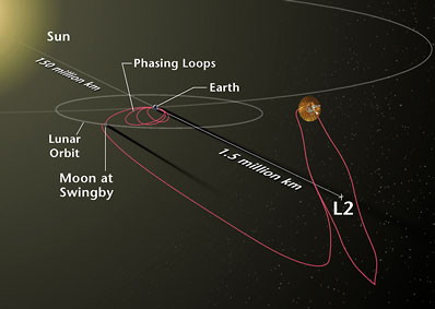
Illustration shows MAP's journey from Earth to L2. Photo: NASA
|
MAP's own propulsion system, and a lunar gravity-assist, will carry the spacecraft to its final destination in orbit around the second Lagrange (L2) point of the Sun-Earth system. L2 is four times farther from the Earth than the Moon in the direction opposite the Sun, or about one million miles (1.5 million kilometers) from Earth. An orbit about the Sun-Earth L2 point provides for a very stable thermal environment and near 100 percent observing efficiency since the Sun, Earth, and Moon are always behind the instruments field of view. MAP will perform a series of "phasing loops" in the Earth-Moon system to place it in the proper position for the lunar flyby, which will occur approximately a month after launch. MAP will reach L2 approximately 3 months after launch. This trajectory is designed to minimize the use of fuel. From L2, MAP will have an unobstructed view of the sky, and will be free from near-Earth disturbances such as magnetic fields and microwave emission.
|
|
|
|
Flight Data File
Vehicle: Delta 2 (7425)
Payload: MAP
Launch date: June 30, 2001
Launch time: 3:46:46 p.m. EDT (1946:46 GMT)
Launch site: SLC-17B, Cape Canaveral, Florida
Satellite broadcast: GE-2, Trans. 9, C-band

Pre-launch briefing
Launch timeline - Chart with times and descriptions of events to occur during the launch.
Ground track - Trace the Delta rocket's trek during launch.
Restricted zone - Map outlining the Launch Hazard Area where mariners should remain clear for the liftoff.
Delta 2 rocket - Overview of the Delta 2 7425-model rocket used to launch MAP.
Mission science - Overview of the scientific objectives of MAP.
Delta directory - See our coverage of preview Delta rocket flights.
|