|
|
|

|
|
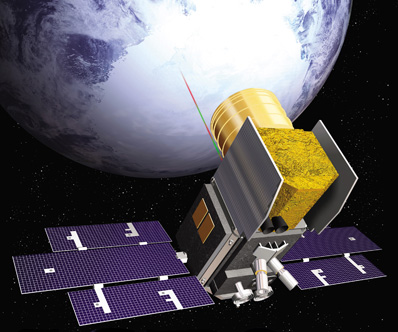
ICESat takes a plunge to conclude successful mission BY STEPHEN CLARK SPACEFLIGHT NOW Posted: August 30, 2010 The ICESat spacecraft fell back into Earth's atmosphere Monday after a seven-year mission to measure the thickness of the planet's land and sea ice, according to NASA.
The satellite fired its thrusters in June and July to reduce the lowest point of its orbit to an altitude of 125 miles, enough for Earth's atmosphere to gradually drag the craft even further down. The 2,000-pound satellite re-entered the atmosphere around 5 a.m. EDT (0900 GMT) Monday over the Barents Sea, according to NASA's orbital debris program office. NASA expected about 200 pounds of ICESat's mass to survive re-entry and reach the surface, according to an agency statement. "The ICESat team has done a marvelous job to ensure that the spacecraft is removed as a hazard to other spacecraft and as a potential source of future orbital debris," said Nicholas Johnson, NASA's chief scientist for space debris. ICESat's primary science instrument, called the Geoscience Laser Altimeter System, stopped producing data in October 2009, when the last of the sensor's three lasers ceased emitting light. Produced at NASA's Goddard Space Flight Center, GLAS monitored ice by firing laser pulses during observation campaigns lasting several weeks about three times per year. Since launch, the instrument completed 15 campaigns and its three lasers executed more than 1.9 billion laser pulses. GLAS accumulated about 15 months worth of data during the mission, according to NASA. The Ice, Cloud, and land Elevation Satellite launched aboard a Delta 2 rocket on Jan. 12, 2003, on a planned three-year mission to gauge changes in the Greenland and Antarctic ice sheets and measure the thickness of sea ice. ICESat also studied vegetation, clouds and atmospheric aerosols. Jay Zwally, ICESat's project scientist at Goddard, said the mission showed the thinning of the Arctic polar ice cap, measured diminishing land ice in Greenland, and proved that Antarctica is not losing as much ice as other studies indicated. "ICESat has been a tremendous scientific success," Zwally said. "It has provided detailed information on how the Earth's polar ice masses are changing with climate warming, as needed for government policy decisions." NASA declared ICESat's mission over in February after several attempts to restore the lost laser system. The agency is developing the follow-on ICESat 2 mission for launch in 2015. In the meantime, NASA researchers are mounting an airborne science campaign called Operation Ice Bridge to fill the gap in data between the loss of ICESat and the launch of the new satellite. |
|
|
|
|
|||||||||||||||||||||