|
|
|

|
|
Landsat fleet hanging on, waiting for reinforcements BY STEPHEN CLARK SPACEFLIGHT NOW Posted: January 13, 2010 The nearly 26-year-old Landsat 5 remote sensing satellite has cheated death once again, but Earth scientists will have to wait three more years for a fresh spacecraft to meet all their research needs.
"Lo and behold, it works," said Bruce Quirk, chief of the United States Geological Survey's land remote sensing program. Science operations could resume this week, according to Quirk. "It's like taking your car and driving into the garage, then coming back 23 years later and starting it up," Quirk said. "For it to work like this, I think it's really remarkable. I wasn't giving it a big chance of working, but Landsat 5 is kind of like the (Energizer) bunny -- it just keeps running and running." Landsat 5 was launched on March 1, 1984, on a three-year mission to continue the Landsat program's legacy of collecting Earth science data for a wide range of applications. "We have brought it from the brink of death and back to life so many times over the last seven years," said Kristi Kline, Landsat program manager at the USGS Earth Resources Science and Observation Center in Sioux Falls, S.D. "It's just amazing what our flight operations team and our engineers are able to do with that spacecraft." Landsat 5 has also recently struggled with other problems, including an August incident that sent the spacecraft tumbling out of control. The satellite's multi-spectral scanner is also not working. "It's the oldest spacecraft of its type still functioning," Kline said. "We've certainly gotten our money's worth out of it." Landsat 5 collected imagery in the aftermath of the Chernobyl nuclear reactor accident and the Sept. 11 terrorist attacks, plus countless other natural disasters. Now approaching its 26th birthday, the spacecraft is now providing scientists with better data than its younger sibling -- the 10-year-old Landsat 7 satellite. That's because part of Landsat 7's imaging instrument stopped working in 2003, significantly reducing the quality of data from the satellite. The faulty part is called the scan line corrector, a mirror-like assembly that compensates for the "zigzag" motion of the image scans by the Enhanced Thermal Mapper Plus instrument. Due to the glitch, each scene is missing about 22 percent of data, leaving gaps that give make some researchers hesitant to use Landsat 7 imagery. "We can't recapture that data," Quirk said. "We worked out several ways to interpolate over the gaps, and we have another method where we take a scene that was collected 16 days before and fill in the gaps."
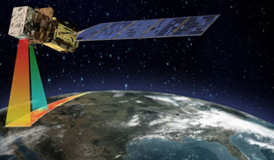
Landsat 5's thematic mapper can collect data in one pass, while Landsat 7 requires multiple flyovers to fill in the gaps. "If Landsat 5 goes out of operation, then it will be much more difficult to form a time series of current data from Landsat 7 data, just because you require multiple images to do it versus just one image from Landsat 5," Tucker said. University of Idaho researcher Richard Allen uses Landsat imagery to study the water cycle, particularly in the American West. "Landsat 5 is our first choice since 2003 due to complete ground coverage of Landsat 5 images as compared to Landsat 7 SLC-off images," Allen said. Kline said the satellites' operators also see a preference for Landsat 5 data, even though Landsat 7 imagery has better resolution and higher accuracy. "With the gaps, some people are reluctant to use [Landsat 7], depending on the study," Kline said. Tucker and Allen are among hundreds of scientists around the world that use daily Landsat imagery for a variety of applications. "Landsat data are a key climate data source," Tucker said. "That's true for vegetation, for the carbon cycle, and it's true for the cryosphere." But like many other U.S. Earth observing satellite programs, Landsat relies on aging satellites well beyond their planned lifetimes. Although both satellites have enough fuel to operate a few more years, many systems are down to backup components that could fail at any time. The Landsat Data Continuity Mission, or LDCM, is scheduled to launch in December 2012 with a thermal infrared instrument and a land imager. Also called Landsat 8, the new satellite will collect more imagery every data and is better equipped to study clouds and observe coastal zones. The thermal instrument was officially added late last year after a campaign by scientists and Congressional representatives from Western states. Quirk said the new thermal instrument is the most worrisome threat to LDCM's launch schedule. Otherwise, there are no serious threats to launch in late 2012.
The thermal infrared sensor can help monitor water distribution and consumption, an important issue in the West. "We rely heavily on the thermal band of Landsats 5 and 7 and on the high-resolution Landsat images that permit determining water consumption on a field by field basis," Allen said. "The latter is important for water rights management." USGS officials believe the Landsat fleet can hold out until LDCM's launch. "With the maneuvers we've been doing to maintain their orbits, and God willing we don't have some kind of an anomaly, we should be able to overlap with the launch and checkout of Landsat 8," Quirk said. But because of the difficulty of predicting the survivability of satellites, the potential of a Landsat data gap "looms large," according to NASA's LDCM Web site. NASA oversees the acquisition and launch of Landsat spacecraft. USGS controllers operate the satellites. The space agency began studying an eighth Landsat spacecraft shortly after the launch of Landsat 7 in 1999. NASA considered putting Landsat instruments on a commercial satellite, then opted to placing a land imager on the next-generation NPOESS weather satellites. But that option added technical issues and mounting costs to the NPOESS program, which was already behind schedule and over budget. The White House intervened in December 2005, directing NASA to procure a dedicated satellite that eventually became LDCM. An interruption in the Landsat program could harm research into climate change, ice fields, the carbon cycle and operational interests in agriculture, land use and resource management. The Landsat program has kept a constant vigil over Earth since the launch of Landsat 1 in 1972. The constellation's nearly 37-year legacy provides a robust archive of data at the fingertips of scientists. "A sizable portion of our greenhouse gas contribution to the atmosphere comes from land use," Tucker said. "And having Landsat data to look back to the 1970s, from there to now, you can then calculate or approximate year-by-year what that contribution is, and that's extremely important." Tucker's specialty is forest research. "In terms of vegetation, it's very useful if you want to study forest biomass and you know an area was cleared 30 or 35 years ago, then you know what the age of the regrowing trees are, and that's very important for determining what the biomass is," Tucker said. Landsat time series are also crucial for keeping track of water, which is a scarce resource in deserts.
Landsat satellites are currently collecting more than 300 scenes per day globally. Those images go into an online archive, providing free access to scientists over the Internet. "What we're seeing is people building up their own archives, and not only pulling down the most recent data over their sites, but they're going back in time and pulling down some of the thematic mapper data from the '80s," Quirk said. Tucker said there are no international satellites offering free access to to Landsat-type data, elevating the urgent need for a U.S. follow-on spacecraft. "This is what the United States has done, and this is why U.S. data are widely used by everyone," Tucker said. "The same is not true of China, the same is not true of India, and the same is not been true of other countries before." A European Space Agency Sentinel satellite scheduled for launch in about four years will collect data comparable to the Landsat system and provide it to international researchers at low costs, but LDCM should be operational by then. It's up to a dedicated control team to keep the remarkable Landsat legacy intact for another three years, long enough for a fresh satellite to take over the mantle. |
|
|
|
|
|||||||||||||||||||||||||