|
|
|

|
|
India readies Israeli radar spysat to eye Pakistan BY CRAIG COVAULT SPACEFLIGHT NOW Posted: April 18, 2009 India is poised to launch a $200 million military imaging radar reconnaissance satellite purchased secretly from Israel to locate hostile Pakistani or terrorist operations at night and during all weather conditions. The secret spacecraft was rushed to completion following the recent terrorist attack in Mumbai, Indian officials say.
Officials at Lockheed Martin tell Spaceflight Now that the satellite will give India a radar reconnaissance imaging capability comparable to the imaging radars carried by the most modern versions of the high-flying U-2 spy plane operated by the U.S. Air Force. The 660-pound RISAT 2 spacecraft is to be launched April 20 on board an Indian Space Research Organization Polar Satellite Launch Vehicle, fired from the Satish Dhawan Space Center at 6:45 a.m. local time, or 0115 GMT. The mission is part of an expanding Indian military space program driven by serious concerns over monitoring Pakistan and terrorist groups like Al Qaeda. The radar satellite will add to the more traditional visual imaging intelligence capability India already has. The country last year launched its first fairly high resolution reconnaissance satellite, but has operated medium and low resolution remote sensing spacecraft for years. Those spacecraft, however, can not see through clouds or at night. The new RISAT spacecraft is being placed in a 342-mile-high orbit, along with a small microsatellite to be used for imaging educational purposes. The new spacecraft was built by Israeli Aircraft Industries MBT Space subsidiary. The radar was developed by its Elta subsidiary. The satellite will monitor the hundreds of mountain valleys that connect India with Pakistan and terrorist hideouts in Afghanistan further north. It should also help keep track of ships at sea that could pose a threat. The satellite is an upgraded version of Israel's TecSAR synthetic aperture radar satellite. Space-based radars are especially good for monitoring rocky mountain valleys for infiltrating vehicles that show up well in radar imagery. The project also illustrates the growing military space ties between India and Israel, which can build highly capable spacecraft but lacks the kind of booster power India has to launch them. Within the last year, India launched the TecSAR radar satellite for Israel and is likely sharing its data downlink and change detection software capability. Indian Space Research Organization officials said the new satellite was rushed to completion "on a war footing" in the wake the terrorist attack in Mumbai. The imaging radar can provide spot, mosaic and strip imaging modes. But its spot mode can focus high-powered radar beams on a small area to build a high resolution picture of what is there. These modes will provide a multitude of different radar "aspect angles" -- views from electronically different directions-- from which to illuminate targets on the ground. While the Indian RISAT 2 mission is readied, the U.S. is also preparing for the launch of two new military satellites on May 5. One will be launched from Vandenberg Air Force Base, Calif., on a United Launch Alliance Delta 2 rocket. But a much different highly advanced imaging intelligence satellite is to be fired into space on the same day from the new Mid-Atlantic Regional Spaceport at Wallops Island, Va. Depending on the launch time and weather conditions, that rocket launch could be easily visible to people in Washington, D.C. The Indian radar satellite and the U.S. missions set for May 5 are at the vanguard of major new U.S. and international military space developments. The programs over the long term span multi-billion dollar replacements just approved by the Obama administration for the extremely high resolution Advanced KH-11 class of electro-optical satellites favored by the intelligence community. President Obama also approved the procurement of additional smaller, more operationally responsive spacecraft favored by the military services. The White House has also just approved the continued procurement of more commercially-based programs like those operated by the DigitalGlobe and GeoEye companies. Unique imaging programs to improve space situational awareness are also underway. The most intriguing of these is the highly secret twin Defense Advanced Research Projects Agency "Mitex" satellites currently prowling geosynchronous orbit at nearly 25,000 miles altitude. The Mitex satellites can secretly sneak up and image spacecraft, like those from China, that are otherwise so far away they are essentially invisible and difficult to characterize. Earlier this year the Mitex satellites traveled from opposite sides of the planet to rendezvous with and inspect a crippled U.S. missile warning spacecraft. Some Chinese and other international space officials are highly critical of the new Mitex capability because if a U.S. satellite can sneak up to take a picture, it could possibly also disable the other satellite without leaving evidence that it had been done by a U.S. satellite. The May 5 Vandenberg mission will involve the first of three new low altitude military surveillance satellites planned for launch this summer. Two others will be launched piggyback in late July on a single Delta 2 fired from Cape Canaveral
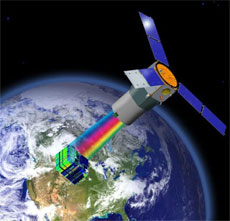
The initial mission May 5 will carry the Northrop Grumman Space Tracking and Surveillance System (STSS) spacecraft for the Missile Defense Agency. The flight will more specifically will be part of the STSS program's Advanced Technology Risk Reduction (STSS-ATRR) research and development flight mission for the agency. The mission was previously called the Block 2010 Spacecraft Risk Reduction satellite. NASA will oversee the Delta 2 launch for the Defense Department. This first satellite will be placed in a relatively low altitude, but high inclination orbit relative to the equator. The Pentagon has not announced the specific orbital parameters to be used. The payload is part of the original "SBIRS Low" infrared sensor development program for the tracking of ballistic missile launches midway through flight. "The STSS Space Tracking and Surveillance test program is designed to provide space-based sensor components for the Ballistic Missile Defense System," the Missile Defense Agency says. The STSS satellites will use special sensors "to detect visible and infrared light for a persistent, global detection, tracking and fire control capability," the agency says The satellite will use a wide-view acquisition sensor, a narrow-view tracking sensor, and a signal and data processor subsystem to detect and track ballistic missile launches, the agency said. The following two SSTS spacecraft are on course for a July 29 Cape Canaveral launch into more of a mid-latitude orbit. Another major military space mission set for launch May 5 is being prepared at the commercial Mid-Atlantic Regional Spaceport where final integration is underway on the $80 million Air Force Research Laboratory TacSat 3 hyperspectral imaging satellite. Raytheon is the primary contractor for the "ARTEMIS" Advanced Responsive Tactically Effective Military Imaging Spectrometer at the core of TacSat 3 while ATK built the spacecraft structure. Hyperspectral imaging is every bit as exotic as it sounds. Systems like the ARTEMIS scanner on TacSat 3 can break wavelengths
of light down into hundreds of bands revealing remarkable details
about the target being imaged.
It will be the third Minotaur military space mission launched from the Mid-Atlantic Regional Spaceport, which although a key new military satellite launch site, has received relatively little notice in the area close to the national capital region. At 65 feet tall with 210,000 pounds of brilliant orange thrust, the Minotaur rockets are easily large enough to be seen from Washington, D.C., roaring into space during night launches at the spaceport. TacSat 3 is to increase the speed and resolution of imagery that can be tasked directly by U.S. battlefield commanders. Instead of waiting on the Air Force or Central Intelligence Agency to call for a picture of a specific area, TacSat 3 is to demonstrate how a small $80 million 21st century satellite can be tasked by a tech-savvy soldier or Marine to quickly obtain a picture that used to require possibly several days to obtain by a $1 billion-class asset like the advanced KH-11 or Lacrosse space-based radar craft. Initiated four years ago in response to military requirements for responsive, flexible and affordable spacecraft, TacSat 3 consists of three unique payloads: the Advanced Responsive Tactically Effective Military Imaging Spectrometer hyperspectral imager, the Office of Naval Research's Satellite Communications Package and the Air Force Research Laboratory's Space Avionics Experiment. Designated as the small satellite's main demonstration, the ARTEMIS payload will provide, within 10 minutes of its collection, target detection and identification information, as well as battlefield preparation and combat assessment data. "Capabilities of the ARTEMIS sensor are that it can identify characteristics by seeing through camouflage and foliage. It can also recognize physical characteristics such as oil and paint," said Thom Davis, TacSat 3 program manager. "It will also demonstrate its ability to provide real-time information to the warfighter via a text message or on a laptop computer. With the data supplied by the spacecraft, the commander in the theater of interest can determine if the object is something to be concerned about or a decoy." In addition, the heart and soul of the spacecraft, a first-generation modular bus, will be evaluated for its operational adaptability for future TacSat flights. TacSat 3 involves a partnership between the Army Space and Missile Defense Command, Air Force Space Command, the Department of Defense's Operationally Responsive Space office at Kirtland Air Force Base, the Office of Naval Research, the National Air and Space Intelligence Center, the National Geospatial Intelligence Agency and AFRL's Sensors Directorate. |
|
|
|
|||||||||||||||||||||||||