|
|
|
|
|
New project to develop GPS-like system for moon OHIO STATE UNIVERSITY NEWS RELEASE Posted: July 22, 2008 COLUMBUS, Ohio -- The same Ohio State University researcher who is helping rovers navigate on Mars is leading a new effort to help humans navigate on the moon.
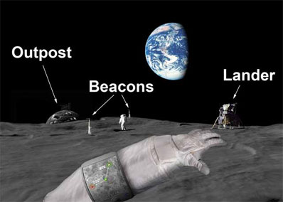
The moon doesn't have satellites to send GPS signals. So NASA has awarded Li $1.2 million over the next three years to develop a navigation system that will feel a lot like GPS to the astronauts that use it, but will rely on signals from a set of sensors including lunar beacons, stereo cameras, and orbital imaging sensors. Li described the project in a poster session Monday at the NLSI Lunar Science Conference, held at NASA Ames Research Center in Moffett Field, California. The new grant grew out of Li's ongoing development of software for the Mars rovers Spirit and Opportunity. Researchers have learned a lot about navigation from exploring the red planet. New technology -- sensors, inertial navigation systems, cameras, computer processors, and image processors -- will make the next trip to the moon easier for astronauts. People are used to having certain visual cues to judge distances, such as the size of a building or another car on the horizon, Li explained. But the moon has no such cues. Getting lost, or misjudging a distant object's size and location would be easy, and extremely dangerous. He described incidents during past lunar missions when astronauts were traveling to a target site such as a crater, and got within a few yards of it -- but couldn't see the crater because of difficult terrain. "They were so close, but they had to turn back for safety's sake," he said. Keeping astronauts safe will be a top priority for Li's team, which includes experts in psychology and human-computer interaction as well as engineering. "We will help with navigation, but also with astronauts' health as well," Li said. "We want them to avoid the stress of getting lost, or getting frustrated with the equipment. Lunar navigation isn't just a technology problem, it's also biomedical." Li explained how the system will work: images taken from orbit will combine with images from the surface to create maps of lunar terrain; motion sensors on lunar vehicles and on the astronauts themselves will allow computers to calculate their locations; signals from lunar beacons, the lunar lander, and base stations will give astronauts a picture of their surroundings similar to what drivers see when using a GPS device on Earth. The researchers have named the entire system the Lunar Astronaut Spatial Orientation and Information System (LASOIS). Li, who leads Ohio State's Mapping and Geographic Information Systems Laboratory, will work with Kaichang Di, a research scientist, and Alper Yilmaz, an assistant professor, both of civil and environmental engineering and geodetic science. Yilmaz works in the the university's Photogrammetric Computer Vision Laboratory. LASOIS partners at NASA Glenn Research Center will convert a pre-existing communications beacon to do double-duty for communication and navigation. Massachusetts Institute of Technology researchers will design the touch-pad that astronauts will wear -- possibly on the arm of their space suits, Li said -- to view their location and search for new destinations. University of California, Berkeley, researchers will work out the visual cues that astronauts will need to find their way, and study the kinds of psychological stress they will experience. According to Li's plan, the team will create a prototype navigation system, then travel to the Mojave Desert to test and refine it. The third year would possibly be spent testing the system on NASA astronauts. NASA would then have several years to incorporate the navigation system into its other lunar technologies before 2020. |
|
|
|
|
|||||||||||||||||||||||||||||||||||||||||