|
|
|
|
|
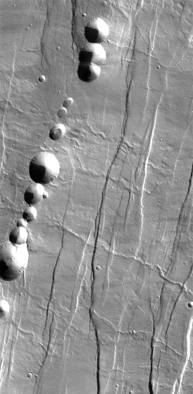
Pit chains hint at recent marsquakes on red planet SOUTHWEST RESEARCH INSTITUTE NEWS RELEASE Posted: October 29, 2004 Strings of depressions dotting the Martian landscape indicate that seismic activity - marsquakes - may still be reshaping the surface of the planet, according to Dr. David Ferrill of Southwest Research Institute in a paper published in GSA Today. These pit chains occur along dilational faults, partially filled or open cavities that served as conduits for past groundwater flow. "These faults could now serve as reservoirs for water or ice, making these locations of potentially great interest to the scientific community searching for signs of life on Mars," said Ferrill, a senior program manager at SwRI. "Astrobiologists consider subsurface aquifer systems high-priority targets for a potential Martian fossil record," said Danielle Wyrick, an SwRI planetary geologist who co-authored the GSA Today article. "Detecting underground water is difficult because current Mars data show only the surface. Pit chains are easy-to-recognize features that give us clues to what’s going on below the surface, including prospective groundwater systems."
"The pit craters are larger and better preserved on Mars than on Earth because the surface erosion and higher gravity on Earth result in smaller pits that are rapidly erased, sometimes within decades," said Ferrill. In many areas of Mars, pit crater chains appear to be some of the youngest features, postdating drainage channels, faulting and impact craters. Using visible spectrum image data of Mars from the Thermal Emission Imaging System on the Odyssey spacecraft, the team mapped pit crater outlines, surface drainage channels and fault traces. Pit craters can be observed at all stages of formation. The smallest pits have apparently flat floors with surface textures similar to the surrounding topographic surface; the steeper pit walls are smooth. "We deduce that some of these pits are youthful, perhaps even actively forming, because surface subsidence has not destroyed the original surface of in-falling material," explained Ferrill. Laboratory physical analog modeling also supports these observations. Based on analysis of Mars data, scientists simulated slip on a normal fault using unconsolidated dry white or dyed sand to represent Mars surface materials. Constant thickness rigid wooden or aluminum plates, with or without an overlying layer of cohesive powder, represented dilating fissures beneath the sand. Scientists initially placed the plates edge-to-edge and created tabular voids by progressively separating the plates to simulate fault slip. "Our physical models reproduced most pit chain morphologies observed on Mars," said Ferrill. SwRI is an independent, nonprofit, applied research and development organization based in San Antonio, Texas, with more than 2,800 employees and an annual research volume of more than $350 million. |
|
|
|
||||||||||||||||||||||