|
 |
|
||||
|
|
||||
|
NASA satellites help improve ocean condition forecasts NASA NEWS RELEASE Posted: January 29, 2004 Freighters, cruise lines, marine rescuers and coastal managers are among those who could benefit from prototype three-dimensional, three-day ocean condition forecasts created with the assistance of NASA satellite data, computer models and on-site ocean measurements.
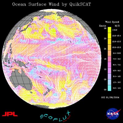
"The end product from our 3-D ocean model includes temperature, salinity and current," Chao said. These are available as text or binary data, or can be visualized for further analysis. Seeing the ocean in three dimensions, and knowing how it will behave from top to bottom, will save fuel costs for large shippers by steering them away from choppy waters, or moving with the current. The data will also help Coast Guard rescuers, as they would be able to better determine which direction people stranded in the water would drift. Multiple sources of measurement provide input into the forecast system. Satellite data include near-real-time wind data from the SeaWinds instrument on NASA's QuikScat satellite; ocean height, including waves, measured from NASA's Topex/Poseidon and Jason satellites; and sea surface temperatures measured by the National Oceanic and Atmospheric Administration's Geostationary Operational Environmental Satellites Advanced Very High Resolution Radiometer instrument. Aircraft data from the Office of Naval Research are used on cloudy days, when satellites cannot see the ocean surface. Ocean water temperature and salinity data are provided by a variety of sensors, such as sea gliders that can dive from the ocean suface to several hundred meters depth, as well as data from ships and autonomous underwater vehicles. Meters measure ocean currents, and shore-based high-frequency radars provide ocean surface current data. Once these data are put into the forecast system, existing ocean conditions are simulated in 3-D, within 24 hours of real-time, and more accurate three-day forecasts are then generated in 3-D. Chao said the NASA 3-D ocean models were useful in planning daily ocean measurement missions during a field campaign conducted last summer in Monterey Bay, Calif. Mission scientists used the forecasts to find interesting areas to observe, such as where cold water from the ocean bottom came up to the surface. Wherever the models seemed to generate an error, more observations were planned, so the forecasts could be improved. Data are only available for Monterey Bay, where the prototype system was first tested, and are not yet available for public use. Further research is planned along an expanded stretch of the U.S. Pacific coastline. The researchers hope to eventually issue round-the-clock operational forecasts along all U.S. coastal areas. In addition to helping with ocean condition forecasts, NASA also is interested in studying the coastal ocean to monitor resources for many purposes including recreation, conservation and commerce. Satellites provide the high-resolution imagery to accomplish this task. NASA and the Office of Naval Research jointly funded this research. Sixteen institutions are evaluating the system or providing data. The forecast system exemplifies NASA's Earth Science Enterprise Coastal Management national application, where agency aerospace research and development of science and technologies are being used with other federal agencies such as the National Oceanic and Atmospheric Administration. JPL is managed for NASA by the California Institute of Technology in Pasadena.
|
|
||||