|
 |
|
||||
|
|
||||
|
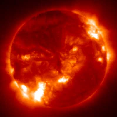
Environmental satellite set to detect solar storms NASA NEWS RELEASE Posted: January 30, 2003
GOES-12 is equipped with an advanced instrument for real- time solar forecasting. The Solar X-ray Imager (SXI) aboard the satellite will enable forecasters and scientists to detect solar storms that could impact billions of dollars worth of assets. "I want to offer my congratulations to the SXI partners on their significant achievements," said Dr. Richard Fisher, Director of the Sun Earth Connection Division at NASA Headquarters. "I view the initiation of the new SXI serivce as a victory for the national scientific research program. Yesterday's research mysteries have become the subject of today's report on space weather conditions," he said. The instrument will take a full-disk image of the sun's atmosphere once every minute. NOAA and the U.S. Air Force will use the images to monitor and forecast the sources of space weather disturbances from the sun. The images will enable forecasters to predict disturbances to Earth's space environment that can destroy satellite electronics, disrupt long-distance radio communications or surge power grids. The ability to monitor and forecast solar disturbances is valuable to operators of military and civilian radio and satellite communications systems, navigation systems, astronauts, high-altitude aviators and scientists. The SXI is a small telescope that makes use of advanced technology and grazing incidence optics to allow it to see the sun's outer atmosphere or corona in X-rays. SXI lets solar forecasters see phenomena they couldn't otherwise view, such as coronal holes, whose high-speed winds cause geomagnetic storms; and to infer solar activity occurring behind the sun's edge, or limb. X-ray images are more accurate than white light imagers for identifying the location of flares. "NASA is excited about providing another fine tool for the NOAA team to use in weather operations, including space weather forecasts," said Martin A. Davis, NASA GOES program manager at Goddard Space Flight Center (GSFC) in Greenbelt, Md. GOES-12 represents a continuation of a 27-year joint program between NASA and NOAA. The United States operates two environmental satellites in geostationary orbit 22,300 miles over the equator. GOES-12 was launched on July 23, 2001, and placed into on-orbit storage. Controllers at NOAA's Satellite Operations Control Center in Suitland, Md., are commanding the satellite out of storage and preparing it for operations. NOAA's National Environmental Satellite, Data, and Information Service operates the GOES series of satellites. After the satellites complete on-orbit checkout, NOAA assumes responsibility for command and control, data receipt, product generation and distribution. GSFC manages the design, development and launch of the spacecraft for NOAA. The SXI was built by NASA's Marshall Space Flight Center in Huntsville, Ala. The images taken by the SXI will be available in real time
to the public via the Internet through NOAA's National
Geophysical Data Center website at: http://www.ngdc.noaa.gov/stp/stp.html
|
Earth Calendar  NEW! This amazing 2003 calendar features stunning images of mountain ranges, volcanoes, rivers, and oceans obtained from previous NASA space shuttle missions�.��
Hubble Calendar  NEW! This remarkable calendar features stunning images of planets, stars, gaseous nebulae, and galaxies captured by NASA's orbiting Hubble Space Telescope�.��
Hubble Posters  Stunning posters featuring images from the Hubble Space Telescope and world-renowned astrophotographer David Malin are now available from the Astronomy Now Store. Stunning posters featuring images from the Hubble Space Telescope and world-renowned astrophotographer David Malin are now available from the Astronomy Now Store. |
||||