|
 |
|
||||
|
|
||||
|
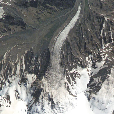
Astronauts capture high-resolution glacier imagery NASA NEWS RELEASE Posted: November 18, 2002 Russian researchers are studying images taken by the crew of the International Space Station to better understand the catastrophic glacier collapse and landslide that occurred on the northern slope of Mount Kazbek in September -- information that may help us better understand our home planet.
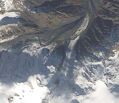
Russian scientists at Moscow State University are using images taken by the crew aboard the Station to measure small changes near the glacier. "We can see a slight increase in the area of a new lake near the Kolka Glacier terminus," said Dr. Olga Tutubalina, a scientist at Moscow State University. "We first sighted this lake during our field trip on Oct. 5, and the lake surface has increased from Oct. 6 to 19. It is potentially dangerous, because it can produce disastrous outburst mudflows," she said.
Dr. Lev Dessinov, of the Russian Academy of Sciences, collaborated with scientists at NASA's Johnson Space Center, Houston, to establish global glacier sites as a research topic for the Crew Earth Observations project. Dessinov was also part of the team of scientists called to the Kolka area immediately after the glacier collapsed. "We collected a lot of information and [NASA astronaut photographs] were one of our main data sources," Dessinov said. The Expedition 5 crew, Commander Valery Korzun, Flight Engineer Sergei Treschev and NASA Station Science Officer Peggy Whitson, have been photographing this area since the beginning of the mission in June as part of the Russian URAGAN and U.S. Crew Earth Observations projects, which are studying changes in the world's glaciers. On Aug. 13, about one month before the glacier collapsed, the crew photographed the mountain. Although scientists have predicted the possibility of large glacial collapses, at the time of the first image, no one predicted that tragedy would strike the mountain village of Karmadon a little more than a month later. On a visit to the Station, Shuttle crewmembers photographed the aftermath of the collapse on Oct. 17. Station crewmembers then took a spectacular three- dimensional oblique image on Oct. 19. The crew has been able to provide international scientists with images, such as those taken for the glacier researchers, by using motion compensation techniques developed by previous Station crews. Crewmembers can use high-magnification lenses to survey features around the world from their relatively low orbit, obtaining spatial resolutions as good as six meters. This means scientists can use photographs taken from the Station to study changes that are occurring in very small features on the Earth's surface. These images can augment satellite data, especially when astronauts take advantage of varying Sun angles on the landscape to capture three-dimensional views. This technique, which was used to take a photo of the glacier area on Oct. 19, provides imagery that is both visually spectacular and easy to interpret. "The (Oct. 19) image gives us a rare opportunity to try and estimate the volume of the initial glacier collapse," said Chernomorets. The first five Space Station crews have taken more than
41,000 images of the Earth using digital still cameras, 35
mm cameras, 70 mm cameras and a variety of lenses.
Crewmembers are able to produce higher-resolution
photographs with the high-magnification lenses by learning
to compensate for the relative motion of the Earth below
them as they point their cameras through a specially built
window in the Station's Destiny laboratory.
|
Hubble Posters Stunning posters featuring images from the Hubble Space Telescope and world-renowned astrophotographer David Malin are now available from the Astronomy Now Store. Stunning posters featuring images from the Hubble Space Telescope and world-renowned astrophotographer David Malin are now available from the Astronomy Now Store.New DVD  The conception, design, development, testing and launch history of the Saturn I and IB rocket is documented in this forthcoming three-disc DVD. The conception, design, development, testing and launch history of the Saturn I and IB rocket is documented in this forthcoming three-disc DVD.Hubble Calendar  NEW! This remarkable calendar features stunning images of planets, stars, gaseous nebulae, and galaxies captured by NASA's orbiting Hubble Space Telescope�.��
The ultimate Apollo 11 DVD  NEW 3-DISC EDITION This exceptional chronicle of the historic Apollo 11 lunar landing mission features new digital transfers of film and television coverage unmatched by any other. NEW 3-DISC EDITION This exceptional chronicle of the historic Apollo 11 lunar landing mission features new digital transfers of film and television coverage unmatched by any other.Hubble  Astronomy Now presents Hubble: the space telescope's view of the cosmos. A collection of the best images from the world’s premier space observatory. Astronomy Now presents Hubble: the space telescope's view of the cosmos. A collection of the best images from the world’s premier space observatory. |
|||||