|
 |
|
||||
|
|
||||
|
NASA study links El Nino and southern ocean changes NASA NEWS RELEASE Posted: March 6, 2002 NASA researchers have found strong relationships between El Nino episodes and changes in climate and sea ice cover around Antarctica. Identifying these relationships is important because it provides new insights into the changing characteristics of the Antarctic region and their role in Earth's climate system.
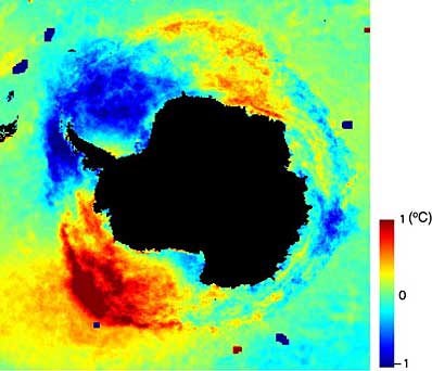
"Understanding the connection between the Southern Oscillation and southern ocean climate and the sea ice cover will substantially improve our understanding of global climate," said Dr. Ron Kwok, a senior research scientist at NASA's Jet Propulsion Laboratory, Pasadena, Calif. "Our study concludes that the southern ocean's climate and ice cover is somehow connected to climate in the tropical latitudes. While we don't know yet the cause-and-effect relationship between the two, we do know the changes in sea ice cover cannot be explained by local climate variations alone and are instead linked to larger scale climate phenomena." The study was conducted by scientists at JPL and NASA's Goddard Space Flight Center, Greenbelt, Md. It is based on data from 1982 to 1999. The NASA scientists also noted changes in sea ice cover in regions not normally associated with El Nino, such as the Weddell Sea east of the Antarctic peninsula. The strongest links were observed to be in the Amundsen, Bellingshausen and Weddell Seas of the west Antarctic, where the connections are localized and well defined. Within these sectors, higher sea level pressure, warmer air temperature and warmer sea surface temperature are generally associated with the El Nino phase. A number of observations in the scientific literature can be explained by this El Nino Southern Oscillation connection. Examples include a record decrease in sea ice coverage in the Bellingshausen Sea from mid-1982 through early 1999; the reduced sea ice concentration in the Ross Sea; and the shortening of the ice season in the eastern Ross, Amundsen and far western Weddell Seas. Four El Nino episodes over the 17 year period occurred at the same time as ice cover retreats in the Bellingshausen and Amundsen seas, showing unique associations between the Southern Oscillation and this region of the Antarctic. "The study shows that the impact of El Nino is global and that processes as remote as those in the polar regions are affected," said co-author Dr. J. Comiso, senior research scientist from NASA's Goddard Space Flight Center. "The effect can be profound since these El Nino episodes affect the Weddell and Ross Seas. These areas are regarded as key sources of cold and dense bottom water that influences global ocean circulation. Also, the ice cover in the Bellingshausen Sea is the habitat for a wide variety of marine life and is crucial to their survival." Data for the study were acquired from several sources, including satellite data from the National Oceanic and Atmospheric Administration, Washington, D.C.; climate data from the joint data set of the National Centers for Environmental Prediction, also in Washington, and the National Center for Atmospheric Research, Boulder, Colo.; sea ice data from the National Snow and Ice Data Center in Boulder; and sea ice motion data from JPL's Remote Sensing Group. The American Meteorological Society is the nation's leading professional society for scientists in the atmospheric and related sciences. The study was funded by the Cryospheric Sciences Program within NASA's Earth Science Enterprise, a long-term research effort dedicated to understanding how human-induced and natural changes affect our global environment.
|
|
||||