|
|
|
|
|
Delta 4 deploys an advanced weather observatory BY WILLIAM HARWOOD STORY WRITTEN FOR CBS NEWS "SPACE PLACE" & USED WITH PERMISSION Posted: June 27, 2009 Running a day late because of stormy weather, a United Launch Alliance Delta 4 rocket boosted a new GOES weather satellite into space Saturday to serve as an orbital spare for the National Oceanic and Atmospheric Administration's fleet of hurricane-tracking weather sentinels.
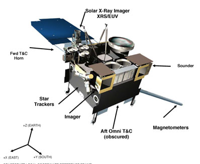
"Three, two, one and liftoff of the Delta 4 rocket with GOES-O, enhancing quality and reliability of the weather satellite for the forecaster," said NASA launch commentator George DIller. It was the 10th flight of a United Launch Alliance Delta 4 rocket since 2002 and the second of three launchings planned for this year. A launch attempt Friday was called off because of thunderstorms and electrical activity near the Cape Canaveral Air Force Station. More of the same was on tap today and forecasters initially predicted a 70 percent chance of a launch delay. Thunderstorms rolled over the launch pad during fueling but conditions improved as the afternoon wore on and after a 37-minute delay to allow a storm cell to move past to the south, United Launch Alliance proceeded with the countdown. The Delta 4's first stage performed normally, boosting the vehicle to an altitude of about 90 miles before falling away four-and-a-half minutes after liftoff. The rocket's second stage then lofted the spacecraft into an initial parking orbit before two additional firings needed to place the 7,000-pound GOES-O satellite into an elliptical transfer orbit with a high point of about 21,800 miles and a low point of 4,100 miles. Spacecraft separation occurred as planned four hours and 21 minutes after launch. On-board thrusters will be used to put the satellite in its final circular orbit 22,300 miles above the equator. That milestone is expected July 8 and if all goes well, Boeing Space and Intelligence Systems will turn the satellite over to the government on July 18. The Geostationary Operational Environmental Satellite system provides the hemispheric views familiar from television weathercasts. Observations of the Atlantic Ocean, the Gulf of Mexico and the East Coast are provided by the GOES-12 satellite - critical for hurricane tracking - with GOES-11 providing similar coverage of the the West Coast and the central Pacific Ocean past Hawaii. GOES-O will be known as GOES-14 once on station, joining the GOES-13 satellite, launched three years ago, as an orbital spare. "GOES-O will provide another important operational asset to NOAA and will become part of the nation's infrastructure for both weather and environmental forecasting," said Steve Kirkner, GOES project manager at NASA.
"The things we're looking for, tornadoes and severe thunderstorms are very small in scale," said Joe Schaefer, director of NOAA's Storm Prediction Center in Norman, Okla. "The increased resolution and accuracy that these satellites will present will help us pinpoint what's happening, and if we know what's happening, we can do a better job of making short-term and long-term forecasts of where it's going to be." Along with saving lives, improved resolution can lower costs as well. "There's an old rule of thumb that if we can evacuate fewer people for a hurricane, for every mile we don't have to evacuate that saves you a million dollars on average," said Tom Wrublewski, technical acquisitions manager for the GOES project. "That translates into savings for you and I ... and being able to know where tornados and other storms are." Like all recent GOES satellites, the two newest models also include space environment sensors to measure energetic particles blown off by the sun, to monitor Earth's geomagnetic field and to look for X-ray and ultraviolet emissions from powerful solar flares that can disrupt communications. "GOES-O is going to better ensure that we have continuous coverage in the decade ahead, it's going to improve our imaging, atmospheric sounding, and our near-Earth space weather environmental measurements that are essential to accurate weather and solar forecasts," said Wrublewski. Along with improve hurricane tracking and forecasting, the new satellites will provide "clearer cloud top and wind products and also better detection of aerosols." "We'll be better able to watch where those volcanic plumes are going and that is very important to airline pilots not to foul their engines," he said. Engineers will check out the new satellite and calibrate its instruments over the next two months to make sure the spacecraft is functioning normally. The first visible-light full-disk image of the Earth is expected around July 28 and an X-ray instrument that will monitor solar flares will send down its initial test image Aug. 6. Once checkout is complete, the satellite will go into storage mode near GOES 13 to await call up as needed. Projections indicate GOES-12 will begin running into fuel-shortage issues late this year, followed by similar issues with GOES-11. The new satellites have a 10-year design life. "We don't really know when we're going to need it," said Marty Davis, an advisor to the GOES project. "We know the two operational satellites that are up there now are not perfect and are becoming less perfect as time goes on. So the next one to be operational will be GOES-13, which was launched three years ago. We don't think we'll have two spares for very long. The prediction is GOES-13 will be made operational by the end of the year."
|
|
|
|
|||||||||||||||||||||||
|
MISSION STATUS CENTER |
||||||||||||||||||||||||||||