|
|
|
|
|
Huygens team releases first enhanced mosaics of Titan UNIVERSITY OF ARIZONA NEWS RELEASE Posted: May 22, 2005 Scientists on Huygens' Descent Imager Spectral Radiometer (DISR) experiment have generated new views of Saturn's giant moon, Titan.
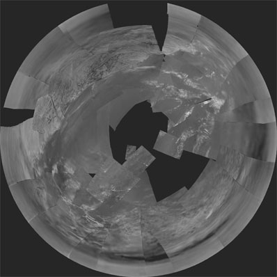
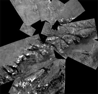
The team now has produced the first enhanced mosaic images. They used special image projection techniques in combining a series of images taken as Huygens rotated on its axis 20 kilometers, or 12.4 miles, above Titan's surface. DISR took a series of photographs of the moon's surface in sets of three, or triplets, as Huygens descended through Titan's atmosphere. The images partially overlap because the probe rotated during the descent and because the fields-of-view of different cameras overlapped. Scientists used physical features seen in more than one image to piece mosaics together like jigsaw puzzles. The new mosaics are stereographic and gnomonic (pronounced 'no-mahn-ic') projections. These are different ways of showing Titan's three-dimensional surface in two dimensions. Stereo projection (above) squeezes the entire visible surface into one image, so it shows size, area, distance and perspective of landscape features, said Mike Bushroe of the UA Lunar and Planetary Laboratory, DISR senior staff engineer. Gnomonic projection is the kind found in maps that navigators and aviators use to determine the shortest distance between two points. Gnomonic projection makes the surface appear flat and distorts scale at the map or mosaic outer edges. In the new stereographic 'fish-eye' view of Titan's surface, the bright area to the north (top of image) and west is higher than the rest of the terrain. The bright area is laced with dark lines believed to be drainage channels leading down to what appears to be a shoreline with river deltas and sand bars. Scientists think the channels are cut by flowing liquid methane. Precipitation run off carved the dense network of narrow channels and features with sharp branching angles, researchers theorize. Sapping or sub-surface flows may have created the short, stubby channels that join at 90-degree angles, they add. The largest run off channel starts at about the 12 o'clock position from an inlet on the shoreline and stretches to the left. The largest sapping channel starts at the 9 o'clock position and continues in a straight line up and left. The dark wide corridor to the west just below the sapping channel is believed to be a major flow channel that empties into the mud flats of the lakebed. The bright shapes to the northeast and east look to be ridges of ice gravel that are slightly higher than the flats around them. The probe is thought to have landed just southwest of the semi-circular shape. Researchers can't yet explain the light and dark areas to the south. The gnomonic projection (below) was made from images taken as the probe approached the landing site, and as surface features sharpened. North is at the top of the image. What appears to be a ridge of ice boulders thrusting up through darker lakebed material runs between lower left and upper right in this mosaic.
University of Arizona Lunar and Planetary Laboratory scientist Martin Tomasko leads the DISR team. Team members are based throughout the United States and Europe, with the largest contributing groups from the UA in the United States, from the Max Planck Institute in Germany, and the Paris Observatory in Meudon, France. The Cassini-Huygens mission to Saturn and Titan is a joint mission of NASA, the European Space Agency (ESA) and the Italian Space Agency (ASI). ESA supplied and manages the Huygens probe that descended to Titan's surface Jan. 14, 2005. NASA's Jet Propulsion Laboratory, a division of the California Institute of Technology in Pasadena, manages the mission for NASA's Science Mission Directorate in Washington, D.C. NASA funded the Descent Imager-Spectral Radiometer, which was built by Lockheed Martin. |
|
|
|
|
||||||||||||||||||||||